
Drone Mapping Services for Surveyors
Survey firm owners usually do not need more drone hype. They need more capacity, more repeatability, and fewer surprises. That is where drone mapping services become commercially useful. A single aerial mission can produce orthomosaics, elevation models, point clouds, surface models, and change-detection datasets that can support design, earthwork verification, stockpile volumetrics, construction monitoring, and site selection. Orthophotos are not just “nice images”; the U.S. Geological Survey defines an orthoimage as a corrected image with uniform scale that can be used as a base map and measured directly, while lidar-derived bare-earth models can reveal terrain obscured by vegetation. At the same time, the operational side is real: commercial drone work sits inside FAA Part 107, registration, Remote ID, controlled-airspace authorization, and, in some situations, waiver requirements.
For most survey firms, the real question is not whether drone mapping is valuable. It is how to add it without building a second business inside the first one.
Introduction
Most survey firms do not wake up wanting to run a drone department. They wake up wanting to finish more work, keep projects moving, protect backlog quality, and say yes to opportunities that currently stretch field crews too thin. Drone mapping services matter because they compress site capture, produce measurable map-based imagery, and generate repeatable models that can support engineering and construction decisions much earlier in the project cycle. In medium and large-scale topographic scenarios, especially open or lightly vegetated terrain, peer-reviewed research shows UAV photogrammetry can be accurate enough for many early engineering uses, can feed BIM or CAD workflows, and is faster than purely point-based acquisition for surface understanding. The same research is equally clear that drones are not a total replacement for conventional instruments in every condition, which is exactly why survey firms benefit from a service model grounded in judgment rather than gadget sales.
That is the lens this pillar page takes. “Drone mapping services for surveyors” is not about replacing surveyors with aircraft. It is about extending the reach of licensed professionals and experienced crews. Aerial mapping gives firms a way to capture continuous site conditions, visualize change over time, reduce unnecessary remobilizations, and produce client-facing deliverables that are easier for engineers, owners, and contractors to understand. USGS guidance on orthoimagery and lidar makes the technical foundation clear: orthophotos behave like a map, and lidar provides high-precision elevation mapping that can even expose what the ground looks like under vegetation.
If your firm needs more topo capacity without adding a full drone department, Book a Call with SmartDrone to review your acreage, deliverables, and whether a buy, outsource, or hybrid path makes the most sense.
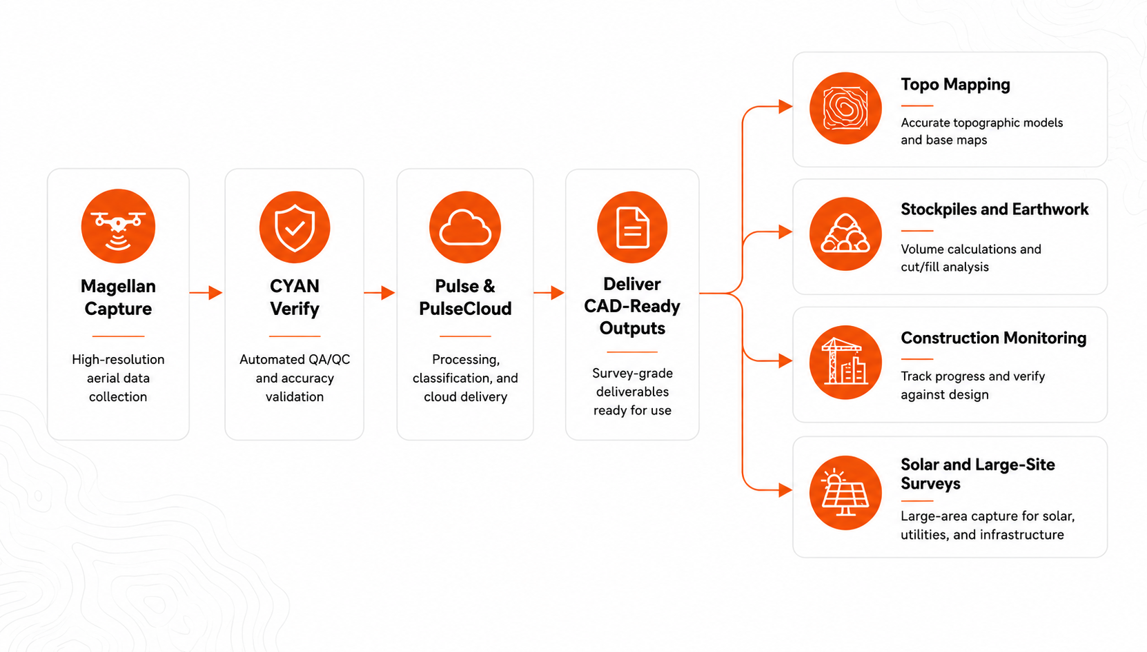
At a practical level, the value of one well-run aerial mission is that it can create several downstream outputs from the same field visit.
These outputs are consistent with USGS definitions of orthoimagery, USGS lidar applications for precise elevation mapping and beneath-vegetation insight, and construction-monitoring literature showing orthophotos, DEMs, and 3D topographic models can be aligned to CAD and BIM for verification.
Expanding Capacity and Getting Better Topography
Drone Survey Services for Survey Firms That Need Capacity Fast
When owners search for drone survey services, speed is usually only part of the problem. The real issue is capacity. A major topo, a sudden bid deadline, a client who wants weekly progress data, or a stretch of repeat work across multiple sites can push a good survey team into a constant tradeoff between urgent field work and profitable field work. Drone mapping services solve that by separating aerial capture from the rest of the survey operation. Instead of asking an already-busy team to learn flight planning, airspace checks, processing software, and QA workflows all at once, the firm can add capacity through a service partner and keep internal staff focused on higher-value surveying judgment. That matters because commercial operators must work inside FAA Part 107 rules, and operations in certain airspace, visual line-of-sight limitations, Remote ID, and special cases may require authorizations or waivers.
A strong drone mapping service should therefore feel less like outsourcing “drone flying” and more like extending your production bench. The right service model handles the flight, the data capture discipline, the processing chain, and the quality handoff so the survey firm receives useful outputs instead of raw complexity. That is especially important for firms that know aerial mapping has a future in their business but do not want to stall growth while they recruit, certify, and ramp an in-house specialist.
When a Drone Topographic Survey Beats Ground Methods on Large, Vegetated Sites
A drone topographic survey beats an all-ground workflow when the biggest problem is not a single critical point but continuous surface understanding across a lot of acreage. Large pads, land development tracts, utility sites, borrow areas, solar footprints, road-adjacent work zones, and phased construction sites all benefit from the same thing: a fast, site-wide baseline that gives teams a surface model and visual context together. Research in construction and topographic mapping supports that use case. In suitable conditions, UAV photogrammetry can be accurate enough for many engineering needs, especially in medium and large-scale topographic applications with lower vegetation, while producing digital terrain and surface products that move efficiently into BIM or CAD-linked workflows.
That does not mean ground methods are obsolete. The better way to think about it is that drones outperform all-ground collection when density, continuity, and speed matter more than collecting every condition with point-wise instruments alone. If one crew can gather a site-wide digital surface in a single mobilization and then use conventional instruments selectively where the project demands extra precision or legal certainty, the combined workflow is often stronger than either method in isolation. The Frontiers study is useful here because it refuses the false choice: UAV-SfM can support early engineering and large-scale topographic work in the right conditions, but there are still applications where conventional geodetic instruments remain the right tool.
Vegetation is the key qualifier in this chapter title. On large sites with scattered vegetation, brush, or broken canopy, drone mapping still improves coverage and context dramatically. But once canopy closure becomes dense and bare-earth extraction becomes the real objective, photogrammetry alone runs into limits. That is why the most credible aerial service partners do not force one sensor onto every project. They help the survey firm decide when photogrammetry is enough, when a hybrid workflow is best, and when lidar is the better answer.
Drone Land Surveying for Repeat Work: Faster Topos, Fewer Return Trips
The most valuable aerial programs are rarely built on one-off wow-factor projects. They are built on repeat work. If your firm surveys the same development every month, the same industrial yard every quarter, the same solar corridor through diligence and construction, or the same earthwork package through phased grading, drone land surveying becomes more powerful with repetition. Permanent control, standard flight plans, repeatable file structures, and consistent deliverables turn aerial mapping from an experiment into an operating system.
That repeatability is not just convenient; it is how quality becomes defensible. The current ASPRS positional-accuracy standards emphasize that ground control should be twice as accurate as the target accuracy of final products, that checkpoints should also be at least twice as accurate as the product specification, and that checkpoint planning should account for both non-vegetated and vegetated areas. ASPRS also notes that the horizontal accuracy of photogrammetrically derived elevation data should be reported explicitly, and that vertical assessment in vegetated terrain requires additional testing. Those standards matter because repeat work is only profitable when the workflow is not just fast, but stable and testable.
NOAA’s National Geodetic Survey adds another useful operational point: photo-identifiable ground control tied to the National Spatial Reference System can be used to georeference imagery, verify the accuracy of existing orthomosaics, supplement photogrammetric control, and reduce time spent sending new field crews to establish control from scratch. For survey firms, that translates into something practical: every repeat aerial project should become easier to run, easier to validate, and easier to deliver cleanly than the project before it.
Turning One Flight Into Repeatable Deliverables
Stockpile Measurement with Drones: Turning Volumetrics into Predictable Revenue
Stockpile measurement is one of the fastest ways for survey firms to turn drone mapping into recurring, predictable revenue. The reason is simple: clients do not need a stockpile measured once. They need it measured again and again—for inventory, reconciliation, operations, reporting, or dispute reduction. That repeat cadence is exactly where aerial volumetrics shine.
The academic evidence is strong enough to matter commercially. In one peer-reviewed comparison of gravel stockpiles, UAV photogrammetry and a conventional ground survey were compared to machine-reported volume. Both methods were close, but the UAV approach was found to be both accurate and time-economical, reinforcing the case for low-cost UAVs as a strong alternative to more time-consuming ground methods for volume estimation. The point is not that drones make conventional methods irrelevant. It is that volumetric work can be delivered faster and more repeatably when the site is captured as a dense surface rather than a limited set of field observations.
From a business perspective, stockpile services work because they are easy for buyers to understand. They do not have to buy into a whole digital-transformation pitch. They just need reliable numbers, delivered regularly, with a method that reduces delay. For the survey firm, that means one aerial capability can open a service line that is easier to schedule, easier to standardize, and easier to renew.
Cut and Fill Analysis with Drones: A Better Way to Verify Earthwork
Cut and fill analysis is where drone mapping stops being “nice context” and starts becoming operationally important. Earthwork is expensive, schedule-sensitive, and vulnerable to misalignment between design, field conditions, and executed quantities. Aerial mapping helps because it gives the survey firm a fast way to establish baseline surfaces, update progress surfaces, and compare the job site the team thinks it has to the job site that actually exists.
Research on road-construction earthwork volume measurement using UAV photogrammetry points to the commercial value directly: UAV methods can streamline the labor and cost associated with traditional earthwork calculations. Separate construction-monitoring research on expressway sites found that repeated UAV photogrammetry produced orthophotos, DEMs, and 3D topographic information models that could be used to verify earthwork and construction progress against 2D CAD and 3D BIM design drawings. That is the real advantage: not only measuring volume, but validating whether the site is moving toward the designed condition on the timetable and at the grade intended.
For survey firms, that improves more than just reporting. Better ground understanding during bidding reduces uncertainty. Better progress surfaces during construction reduce the odds that errors hide until they are expensive. Better verification after regrade or placement reduces rework conversations that otherwise turn into blame conversations. Drone mapping will not replace surveying judgment in earthwork. It does make that judgment faster, better informed, and more visible to project stakeholders.
Construction Drone Mapping Without Owning a Fleet
Construction drone mapping is often where survey firms realize they do not actually need a fleet to create a drone-enabled service line. What they need is dependable access to aerial capture and a system for turning that capture into valuable project outputs. The construction literature is useful here because it shows the deliverables owners and contractors actually care about: orthophotos, elevation products, and 3D topographic models that can be compared to design information over time. In the Korean expressway study, repeated UAV surveys made it possible to monitor changes, observe monthly site progress, and verify location and height by overlapping outputs with both CAD and BIM drawings.
This is exactly why outsourced or hybrid construction drone mapping can work so well for survey firms. The survey firm does not need to own every aircraft, maintain every sensor, and hire every pilot before it can sell useful aerial services. It can add value by defining coordinate systems, project controls, tolerances, deliverable expectations, and client communication while a capable aerial partner handles capture and processing within a repeatable workflow.
That model is especially attractive when the work is episodic. If a firm has bursts of construction monitoring across several months, then quiet periods, building a full-time internal flight team may not pencil out yet. Outsourcing or hybridizing the aerial piece lets the owner test demand, protect margin, and learn which project types justify deeper internal investment later.
See how that would work inside your current workflow? Request a Demo from SmartDrone and map the handoff from Magellan capture to Pulse processing to CYAN verification before the next construction cycle hits your backlog.
Orthomosaic Mapping for Surveyors Who Need CAD-Ready Context
Orthomosaic mapping matters because not every stakeholder reads a point cloud. Engineers, civil designers, owners, and constructors often need context before they need complexity. USGS defines an orthoimage as a corrected aerial image with uniform scale that can be measured directly and overlaid with other map information. That is why orthomosaics are so useful in surveying workflows: they make the site legible to more people without sacrificing map behavior.
For survey firms, “CAD-ready context” is bigger than a pretty image. It means the visual base layer is georeferenced, measurable, and aligned closely enough to support design discussion, feature confirmation, utility planning, grading review, and progress communication. Construction-monitoring literature reinforces this by showing that orthophotos can be combined with DEMs and topographic models and checked against CAD and BIM drawings to verify work status. In other words, orthomosaics are useful not because they replace survey data, but because they help other project participants interpret that data faster and with fewer misunderstandings.
Where survey firms get the most value is in pairing orthomosaics with the right companion outputs. A client who sees only the orthomosaic may feel informed. A client who receives the orthomosaic plus a terrain model, extracted deliverables, and a clear explanation of what changed is much more likely to see the survey firm as strategic rather than transactional.
LiDAR, Provider Selection, and Solar Growth
LiDAR Topographic Mapping in Forested Areas: What Traditional Methods Miss
LiDAR is the answer when the site challenge is no longer just scale, but visibility. USGS states plainly that by processing lidar point clouds into bare-earth DEMs, vegetation can be stripped away to reveal slopes and features hidden by forest canopy. USGS also notes that lidar is widely used for high-precision elevation mapping and can provide insight into what the ground looks like beneath vegetation because laser pulses can pass between leaves and branches. That combination—precision plus beneath-canopy terrain—is why lidar has become essential for forested topographic work.
Academic and technical sources reinforce the same point. A forest-environment UAV-lidar study reported that integrated UAV-lidar systems can acquire high-resolution 3D point clouds below canopy and vegetation, overcoming a major limitation of aerial photogrammetry for terrain extraction in dense cover. Earlier forest lidar research also found that airborne laser scanning could produce terrain models with strong vertical performance, even across substantial vegetation variation. The practical lesson for survey firms is not that lidar is magic. It is that once the ground itself is hidden from standard imagery, you need a sensing method designed to recover terrain rather than infer it from visible surfaces alone.
There is also an important discipline point here. LiDAR is not just “more accurate” by default. Accuracy depends on flight altitude, project design, canopy conditions, control, processing, and verification. Recent research notes that canopy cover and flight altitude materially affect understory terrain estimation. That is why the best aerial partners do not sell lidar as a shortcut. They sell it as the right tool for the right surface problem.
How to Choose a Drone Survey Service Provider in Your Region
The best way to choose a provider is to ignore the marketing language and inspect the operating discipline behind it. Start with compliance. Commercial providers should be fluent in FAA Part 107, understand when airspace authorization is required, know how LAANC works, and be able to explain how they handle Remote ID and exceptions. The FAA is explicit that pilots in controlled airspace around airports must obtain authorization before flying, that LAANC automates that process for eligible operations, and that operations outside standard Part 107 limits may require waivers. If a provider cannot explain that clearly, it is hard to trust the rest of the workflow.
Then move to accuracy and QA. A serious provider should be able to talk through control, checkpoints, vegetated versus non-vegetated testing, metadata, and how the final outputs will be reported against project requirements. ASPRS is especially useful here: the standards require control and checkpoints to be more accurate than the final product, emphasize checkpoint planning across land cover, and expect horizontal and vertical accuracy to be stated and tested appropriately. NOAA’s NGS material adds another practical screen: ask whether the provider understands how imagery ground control is tied to the National Spatial Reference System and how existing control can be used to verify orthomosaics or supplement acquisition planning.
Next, ask about deliverables, not just capture. Can the provider deliver orthomosaics, terrain models, point clouds, volume outputs, and CAD-friendly files in the coordinate system your firm uses? Can they explain where photogrammetry is appropriate and where lidar is warranted? Do they help you move from raw data to client-ready information? Construction-monitoring studies and USGS orthoimage guidance both point in the same direction: the value is in map-grade, measurable outputs that support interpretation and verification, not in file dumps.
Finally, ask whether the support model fits your growth plan. Some firms need a pure outsourced path today. Others want to buy equipment but lean on outside support while they ramp. Others want a hybrid path for long-term growth.
Why Solar Farm Site Surveys Are Moving to Drone LiDAR
Solar is one of the clearest growth markets for drone mapping services because the projects are large, the land requirements are substantial, and the siting decisions are unforgiving. The U.S. Department of Energy notes that ground-mounted solar is projected to require roughly 5.7 million acres by 2035 and as much as 10 million acres by 2050, and that decisions made during siting, permitting, engineering, and construction materially affect community, ecological, and land-use outcomes. Lawrence Berkeley National Laboratory’s utility-scale solar data update tracks a U.S. sector that now includes project-level data on 1,760 ground-mounted utility-scale projects installed through 2024. That is a lot of acreage, and a lot of need for large-site surveying and repeat data collection.
What makes solar especially well-suited to aerial surveying is not just scale. It is the combination of scale and screening complexity. NREL’s solar resource and infrastructure assessment guidance emphasizes that technical-potential screening depends on geospatial data and that localized topography, slope, interconnection opportunities, parcel size, protected land, floodplains, wetlands, and land-cover constraints all shape which sites are actually feasible. The same guidance notes that slope data can be used to screen out very steep sites and that some local rules restrict development on grades of 15% or higher. It also makes clear that total project footprint includes not just panel rows, but access roads, stormwater features, and disturbed area.
This is exactly why solar farm site surveys are moving toward drone lidar, especially on rolling, partially vegetated, or previously disturbed land. Survey firms need fast topographic understanding, reliable bare-earth modeling where vegetation complicates imagery, and repeat monitoring across phases: diligence, conceptual layout, grading, construction, and closeout. Drone lidar is well matched to that sequence because it combines large-area capture with terrain recovery, where canopy or brush would otherwise force slower and more fragmented ground acquisition. For survey firms, solar is not just a niche. It is a multi-phase, repeat-work market where the right aerial partner can create durable recurring revenue.
Choosing the Right Drone Mapping Services Partner for Long-Term Growth
Long-term growth comes from choosing a partner who reduces complexity, not one who sells complexity back to you. That is the strategic test. If your aerial workflow adds pilot staffing pressure, software backlog, QA ambiguity, and support delays, then even technically good data can become commercially bad data. Survey firm owners need the opposite: clear pathways to capacity, dependable support, and a workflow that continues to make sense as the firm moves from isolated projects to repeat programs.
That is why the operating model matters as much as the aircraft or sensor.
That comparison is not theoretical. FAA compliance, airspace authorization, registration, Remote ID, and waiver knowledge are real operating requirements, while ASPRS accuracy expectations and control/checkpoint discipline are real technical requirements. A good partner should make those obligations manageable. A bad one will simply relocate the burden.
FAQs
Are drone mapping services accurate enough for professional survey work?
They can be, but only when the project design matches the site and the accuracy requirements are stated, controlled, and tested properly. ASPRS requires that control and checkpoints be more accurate than the final product and that testing account for land cover, including vegetated terrain. Research also shows UAV photogrammetry is effective in medium and large-scale topo work under ideal site conditions and lower vegetation, while some precision-sensitive tasks still require conventional geodetic methods.
When should a survey firm choose lidar instead of photogrammetry?
Choose lidar when the project depends on recovering bare-earth terrain through vegetation, when canopy materially limits photogrammetric visibility, or when surface precision under difficult cover is the core challenge. USGS explains that lidar-derived bare-earth models can strip away vegetation and reveal slopes and features hidden by canopy, and forest-environment UAV-lidar research shows below-canopy 3D terrain capture can overcome a key limitation of aerial photogrammetry.
Can we use drone mapping services without hiring an in-house pilot?
Yes. That is one of the strongest reasons firms outsource or start with a hybrid model. Commercial drone work still requires FAA-compliant operations under Part 107, registration, Remote ID, and in many cases airspace authorization through LAANC or, if needed, waivers. A capable service partner can absorb that operational overhead while your survey firm stays focused on project requirements, controls, and client delivery.
What deliverables should survey firms expect from a drone mapping provider?
At minimum, ask for the deliverables that match the decision your client needs to make: orthomosaic, point cloud, DEM or DTM, extracted surfaces or contours where needed, and volume or change outputs for recurring work. USGS notes that orthoimages can be measured directly and overlaid with other map information, while construction-monitoring studies show orthophotos, DEMs, and topographic models can be compared to CAD and BIM drawings for verification.
How should we evaluate a provider’s quality?
Ask about control, checkpoints, coordinate systems, land-cover-specific QA, metadata, and how the provider reports horizontal and vertical accuracy. ASPRS gives a strong framework for all of that, and NOAA’s NGS guidance shows how proper photogrammetric control can georeference imagery and help verify orthomosaic accuracy. In short, the provider should be able to explain not just how they capture data, but how they prove it is fit for the stated purpose.
Why is solar such a strong opportunity for drone mapping services?
Because the market is large, land-intensive, and highly dependent on terrain and site-screening quality. DOE projects substantial land use for ground-mounted solar over the coming decades, and NREL guidance makes clear that slope, topography, interconnection, parcel size, protected land, and site conditions all influence what is buildable. That creates recurring survey demand across siting, diligence, grading, and construction phases—exactly the kind of repeat work where drone mapping services perform well.
Conclusion
Drone mapping services are most valuable to survey firms when they solve a business problem first and a technology problem second. The business problem is usually capacity: too much acreage, too much repeat work, too much remobilization, or too much client pressure for fast, site-wide answers. The technical answer is then chosen to fit that problem. Photogrammetry is powerful for many medium and large-scale topographic and construction uses in the right conditions. Orthomosaics provide measurable map-grade context. Lidar becomes indispensable when terrain hides under vegetation or when bare-earth recovery is the real job. And all of it has to be wrapped in FAA-compliant operations and defensible QA if it is going to support a professional surveying workflow.
For the right survey firm owner, SmartDrone’s value is that it keeps this practical. No drone expert required. A defined Magellan, Pulse, and CYAN workflow. U.S.-based support. And the freedom to buy, outsource, or blend the two in the way that best supports growth. That is the kind of partner model that helps firms take on more work without letting the aerial side become an operational distraction.
Grow your mapping capacity without building a full drone department first.
Book a Call with SmartDrone to review your current backlog, your deliverable mix, and the fastest path to a buy, outsource, or hybrid aerial workflow that fits your firm.